Storms that stay too long: scientists explore jet stream, arctic ice role
By Doug Struck
Globe Correspondent
The latest event in a spate of strange and fierce weather always prompts a question to scientists: does this come from climate change?
The usual answer from wary researchers: Well, no one weather event can be attributed to climate change.
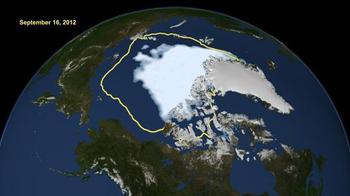
But a researcher at Rutgers University believes that for many kinds of weather, the answer is a much more affirmative “yes.” Her explanation for that link also answers the question of why we should care about those maps and photos of the shrinking Arctic ice cap.
Jennifer Francistold a recent conference on the Arctic warming at Tufts University that the warming polar region is changing the pattern of the jet stream. That stream, all-important in the weather we see in the northern hemisphere, is created when air flows “down” toward the Arctic from the rising warm air of the temperate region. As the earth rotates, it spins this flow to the right, creating the jet stream.
Francis, a research professor at the Institute of Marine and Coastal Sciences at Rutgers, said the Arctic is warming two-to-three times faster than the rest of the atmosphere, and that slows the speed of the air sliding toward the north.
Like a slower-moving river, the jet stream then meanders more, snaking further north and south, which in turn brings to a crawl the usual west-to-east movement of weather patterns across the northern hemisphere. When that happens, local weather systems linger and grow: droughts become more severe, wet weather creates more floods, and – as New England saw this winter—nor’easters can barrel up the Atlantic coast as the usual traffic of new weather systems from the west is stalled.
This pattern, which creates what the weathermen describe as “blocking” high or low-pressure areas, helped steer Hurricane Sandy up the coast in October, and left the middle of the United States vulnerable to a succession of tornadoes, Francis said. It has left Great Britain in a funk of seemingly endless cold wet weather this spring, and produced an
unusual spell of warm weather over Greenland, accelerating the ice melt there.
“What we are finding is that these north-south swings in the jet stream are getting larger, and when they get larger it increases the likelihood of creating “blocks,” Francis said in a telephone interview.
This model does not account for all extreme weather events, but it helps explain the relationship between the warming climate and the documented rise in extreme weather events over the past four or five decades, she said.
William Moomaw, who co-hosted the Tufts conference with Crocker Snow, director of the Edward R. Murrow Center at Fletcher School, said the theory makes sense. “All weather is imbedded in the climate of today,” and thus affected by a warming of the planet,
he said.
With the retreat and the thinning of sea ice in the Arctic region, there is 80 percent less volume of ice than 30 years ago, Francis said. The remaining ice is “broken, thin and fragile.” Francis said it seems obvious that a warming Arctic would have profound effects on the global weather system.
This theory is “an explanation for why we see the kinds of events that seem to be increasing,” she said. “It’s another aspect of climate change that I think we can link directly to changes in weather patterns.”
(Photo credit: NASA)

